Colorado Fatal Accident Study:

Colorado’s Deadliest Roads and Fatal Accident Statistics

Updated: November 1, 2024

Advertising & Editorial Disclosure

Colorado Deadly Road Map

MoneyGeek analyzed the 1,706 deadly crashes that occurred in Colorado between 2018 and 2020 to understand what contributes to fatal accidents in the state. Out of the 185,486 miles of road in the Centennial State, MoneyGeek's analysis focused on 758 roads.

We explored how hazardous driving behaviors were involved in fatal accidents. Our data showed how many deadly crashes involved distracted driving, speeding or drunk driving. Another angle our analysis considered was which month most of these incidents happened.

Our study also presented data for Colorado's counties and identified the deadliest stretch of road in each.

Key Findings

  • W. Colfax Avenue from Ingalls Street to N. Broadway is the deadliest stretch of road in Colorado. Between 2018–2020, 17 fatal accidents occurred here.
  • Out of the 1,706 deadly crashes in Colorado, nearly three-quarters involved speeding or drunk driving. Speeding was a factor in 38.9% of fatal accidents, while drunk driving contributed to 33.6% of crashes.
  • Distracted driving was a factor in 8.3% of accidents. That’s 141 crashes resulting in fatalities.
  • August had the most deadly accidents of any month between 2018–2020. The number of fatal crashes totaled 193 (11.3%). July and June had the next highest counts, with 183 (10.7%) and 178 (10.4%), respectively.
  • El Paso County had the highest number of fatal crashes of any county. The majority of these accidents (28) happened on I-25.

10 Deadliest Road Stretches in Colorado


  • 1. W. Colfax Avenue from Ingalls Street to N. Broadway
    Cities:Lakewood | Denver
    W. Colfax Avenue from Ingalls Street to N. BroadwayLakewood | Denver

    • 17Fatal Accidents
    • 18fatalities
    • 4Crashes Per Mile
    • 4.1 milesdistance
    • (39.74042222, -105.0639333)start
    • (39.74, -104.9874306)end
    • [ 0 2 4 5 6 7 8 9 11 12 13 14 15 16 17 18 19]points
    • 71ordering
    • {'Lakewood', 'Denver'}localities
    • {'Jefferson', 'Denver'}counties
    • TRUEintersect
    • US-40 W Colfax AveTWAY_ID

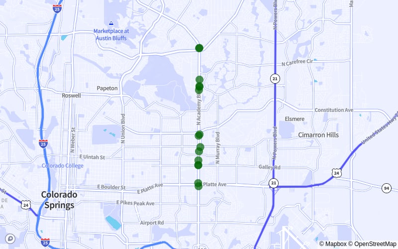
  • 2. N. Academy Boulevard from Austin Bluffs Parkway to E. Platte Avenue
    Cities:Colorado Springs
    N. Academy Boulevard from Austin Bluffs Parkway to E. Platte AvenueColorado Springs

    • 15Fatal Accidents
    • 15fatalities
    • 4Crashes Per Mile
    • 3.6 milesdistance
    • (38.89169444, -104.7569444)start
    • (38.83920556, -104.7573417)end
    • [ 1 2 3 4 5 6 7 9 10 11 12 13 14 17 18]points
    • 62ordering
    • {'Colorado Spgs', 'Colorado Springs'}localities
    • {'El Paso'}counties
    • TRUEintersect
    • N Academy BlvdTWAY_ID

  • 3. S. Academy Boulevard from Airport Road to Ronald Reagan Highway
    Cities:Fountain | Colorado Springs
    S. Academy Boulevard from Airport Road to Ronald Reagan HighwayFountain | Colorado Springs

    • 12Fatal Accidents
    • 12fatalities
    • 3Crashes Per Mile
    • 4.3 milesdistance
    • (38.82541667, -104.7576)start
    • (38.7651, -104.7776944)end
    • [ 0 1 2 3 4 5 6 7 8 9 10 11]points
    • 33ordering
    • {'Colorado Spgs', 'Fountain', 'Colorado Springs'}localities
    • {'El Paso'}counties
    • TRUEintersect
    • S Academy BlvdTWAY_ID

  • 4. E. Iliff Avenue from S. Tower Road to S. Jamaica Street
    Cities:Aurora
    E. Iliff Avenue from S. Tower Road to S. Jamaica StreetAurora

    • 11Fatal Accidents
    • 12fatalities
    • 2Crashes Per Mile
    • 4.8 milesdistance
    • (39.67729722, -104.7723667)start
    • (39.67478333, -104.8626278)end
    • [ 0 1 2 3 4 5 6 7 8 9 10]points
    • 25ordering
    • {'Aurora'}localities
    • {'Arapahoe'}counties
    • TRUEintersect
    • E Iliff AveTWAY_ID

  • 5. I-25 from Exit 138 to Exit 132A
    Cities:Colorado Springs | Fountain
    I-25 from Exit 138 to Exit 132AColorado Springs | Fountain

    • 8Fatal Accidents
    • 9fatalities
    • 2Crashes Per Mile
    • 4.9 milesdistance
    • (38.78590278, -104.7901944)start
    • (38.72916667, -104.7368889)end
    • [17 27 37 51 60 73 80 84]points
    • 13ordering
    • {'Not Applicable', 'Colorado Spgs', 'Fountain'}localities
    • {'El Paso'}counties
    • TRUEintersect
    • I-25TWAY_ID

  • 6. E. Colfax Avenue from Boston Street to Norfolk Street
    Cities:Aurora
    E. Colfax Avenue from Boston Street to Norfolk StreetAurora

    • 8Fatal Accidents
    • 8fatalities
    • 2Crashes Per Mile
    • 4.4 milesdistance
    • (39.740125, -104.8798278)start
    • (39.74015, -104.7972389)end
    • [ 1 2 3 4 6 8 9 10]points
    • 15ordering
    • {'Aurora'}localities
    • {'Adams', 'Arapahoe'}counties
    • TRUEintersect
    • US-40 E Colfax AveTWAY_ID

  • 7. S. Wadsworth Boulevard from W. Jewell Avenue to W. 23rd Avenue
    Cities:Lakewood
    S. Wadsworth Boulevard from W. Jewell Avenue to W. 23rd AvenueLakewood

    • 7Fatal Accidents
    • 8fatalities
    • 2Crashes Per Mile
    • 4.7 milesdistance
    • (39.68216111, -105.0813528)start
    • (39.75087778, -105.0814944)end
    • [0 1 2 3 4 5 6]points
    • 10ordering
    • {'Lakewood'}localities
    • {'Jefferson'}counties
    • TRUEintersect
    • SR-121 S Wadsworth BlvdTWAY_ID

  • 8. I-70 from Exit 277 to Exit 282
    Cities:Denver
    I-70 from Exit 277 to Exit 282Denver

    • 7Fatal Accidents
    • 7fatalities
    • 1Crashes Per Mile
    • 4.9 milesdistance
    • (39.77881111, -104.9260056)start
    • (39.77289167, -104.8338333)end
    • [ 8 21 47 50 54 55 65]points
    • 10ordering
    • {'Denver'}localities
    • {'Denver'}counties
    • TRUEintersect
    • I-70TWAY_ID

  • 9. I-225 from E. Mississippi Avenue to Exit 2B
    Cities:Aurora
    I-225 from E. Mississippi Avenue to Exit 2BAurora

    • 6Fatal Accidents
    • 8fatalities
    • 1Crashes Per Mile
    • 4.5 milesdistance
    • (39.69629444, -104.829425)start
    • (39.64257778, -104.8780722)end
    • [1 2 4 5 6 7]points
    • 8ordering
    • {'Not Applicable', 'Aurora'}localities
    • {'Arapahoe'}counties
    • TRUEintersect
    • I-225TWAY_ID

  • 10. CanAm Highway from Weld County Road 6 1/4 to County Road 14 1/2
    Cities:Fort Lupton
    CanAm Highway from Weld County Road 6 1/4 to County Road 14 1/2Fort Lupton

    • 6Fatal Accidents
    • 7fatalities
    • 1Crashes Per Mile
    • 4.3 milesdistance
    • (40.03311111, -104.8186111)start
    • (40.09464444, -104.81225)end
    • [ 5 6 21 30 32 33]points
    • 8ordering
    • {'Fort Lupton', 'Not Applicable'}localities
    • {'Weld'}counties
    • TRUEintersect
    • US-85TWAY_ID

Drunk Driving Involved in 33.6% of Fatal Accidents

With 1,706 fatal crashes occurring in Colorado between 2018 and 2020, our analysis found that drunk driving contributed to 33.6% of these incidents. That's 574 collisions resulting in fatalities.

Drinking and driving are never a good combination. Even the smallest amount of alcohol in your system impairs your driving abilities. For example, a blood alcohol concentration (BAC) of 0.08% makes you legally drunk in Colorado. However, a lower BAC already puts you and your passengers in a dangerous situation.

Your BAC reaches 0.02% after about two alcoholic drinks. At this point, you may have difficulty tracking a moving object (such as pedestrians or other vehicles) and multitasking.

Even in situations that don't lead to fatal accidents, drunk driving can leave you with long-term and potentially expensive repercussions. The cost of drunk driving isn't limited to paying fines. You might also lose your driving privileges and face jail time if caught.

A DUI on your record makes finding cheap auto insurance in Colorado challenging. You'll need to secure SR-22 insurance in Colorado, which costs more than other coverage types.

Speeding Is a Factor in 38.9% of Fatal Crashes

Between 2019 and 2020, the number of speeding-related fatalities in the U.S. increased by around 17%. In Colorado, speeding was a factor in 38.9% of all deadly crashes recorded. Out of 1,706 fatal collisions, 664 involved speeding.

Driving above the allowable speed limit can present multiple hazards. For example, controlling your car becomes more challenging, making a crash more likely. A higher driving speed also increases a collision's impact — you're more likely to sustain severe injuries in an accident.

Distracted Driving Contributed to 8.3% of Fatal Accidents

Although distracted driving only contributed to 8.3% of deadly crashes from 2018 to 2020, that's still 141 recorded incidents. Colorado is currently running its Distractions Reactions Campaign, highlighting the dangers of distracted driving.

Besides that, Colorado state law prohibits minors from using mobile phones while behind the wheel. Adults, in comparison, can take regular calls as long as they wear headphones. However, they cannot use their cellphones to send text messages either.

August Had More Fatal Accidents Than Any Other Month

According to MoneyGeek's analysis, August was when the most deadly crashes occurred. The recorded incidents totaled 193, accounting for 11.3% of all fatal accidents in Colorado between 2018 and 2020.

July and June were the months with the following highest figures. Each recorded 183 (10.7%) and 178 (10.4%) fatal collisions, respectively.

Driving Safely Protects You, Others and Your Wallet

Being a safe driver doesn't just benefit Colorado's roadways — it helps you save money in the long term. Sometimes, accidents are unavoidable. No matter how careful you are, you might find yourself involved in one, which is why having auto insurance is crucial. A full coverage car insurance policy protects you and your passengers after a crash.

MoneyGeek puts the average cost of car insurance in Colorado at $1,450 per year. However, your premium may vary depending on where you live. For example, drivers looking for car insurance in Aurora spend around $1,512 per year, on average. In comparison, auto insurance in Fort Collins costs $400 less, at $1,112 annually. You’ll pay an average of $1,447 per year for car insurance in Denver — the state's most populous city.

Remember that MoneyGeek's analysis presents averages. Providers may offer you varying rates based on your unique profile, which considers factors like your age and driving history. It's best to compare estimates to help you find the cheapest car insurance company for your needs.

Fatal Accidents and Most Dangerous Roads: County Breakdown

Out of the total number of incidents in Colorado, the top five counties with the most deadly accidents make up 44% of all deadly crashes. That's 815 fatal accidents recorded from 2018 to 2020.

The county with the highest figure was El Paso, with 219 deadly crashes. Most of these accidents involved drunk driving (96) or speeding (86) and happened along I-25.

Methodology

For this analysis, MoneyGeek utilized 2018, 2019 and 2020 fatality data from the National Highway Traffic Safety Administration Fatal Accident Reporting System's (FARS) database. Currently, 2020 is the latest data available in the system.

About Doug Milnes, CFA


Doug Milnes, CFA headshot

Doug Milnes is a CFA charter holder with over 10 years of experience in corporate finance and the Head of Credit Cards at MoneyGeek. Formerly, he performed valuations for Duff and Phelps and financial planning and analysis for various companies. His analysis has been cited by U.S. News and World Report, The Hill, the Los Angeles Times, The New York Times and many other outlets.

Milnes holds a master’s degree in data science from Northwestern University. He geeks out on helping people feel on top of their credit card use, from managing debt to optimizing rewards.


sources