Pennsylvania Fatal Accident Study:

Pennsylvania’s Deadliest Roads and Fatal Accident Statistics

Updated: November 1, 2024

Advertising & Editorial Disclosure

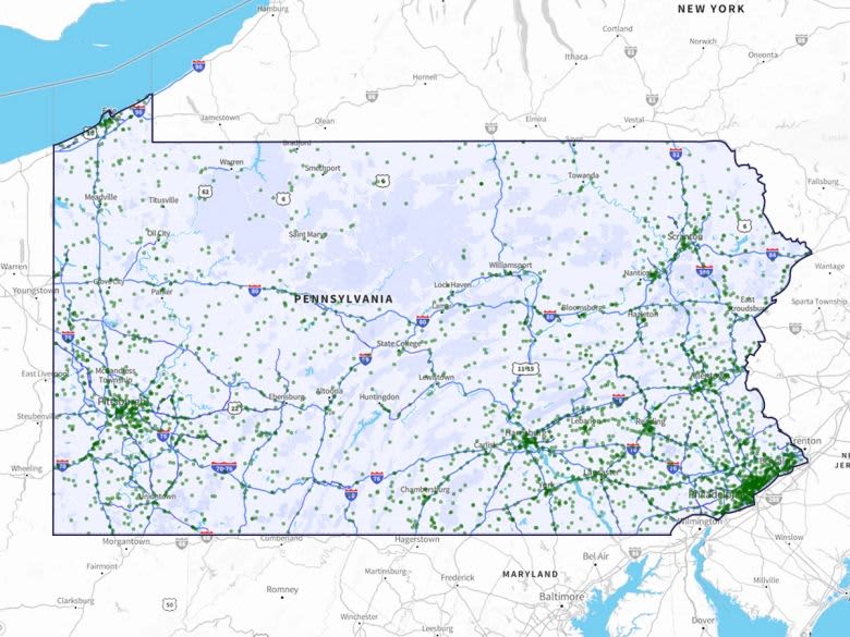
Pennsylvania Deadly Road Maps

MoneyGeek examined 3,176 fatal crashes in Pennsylvania from 2017 to 2019 to learn more about where these crashes occur in the state. We looked at 2,160 roads out of the state’s 251,708 miles of road for this analysis. Our guide breaks down the deadliest stretches overall and by county.

We also explored the various factors that contributed to these accidents. These included driver behaviors, such as speeding, distracted driving and drunk driving. MoneyGeek also considered environmental factors, such as time of year and weather conditions.

Key Findings

  • US-1 Roosevelt Blvd. from W. Wyoming Ave. to Hartel Ave. in Philadelphia is Pennsylvania’s deadliest stretch of road. From 2017 to 2019, 22 fatal crashes occurred there.
  • Speeding contributed to 39.6% of accidents, the highest percentage of any factor measured. Drunk driving was the second-most common factor (25.3%), followed by distracted driving (6.1%).
  • October had 319 deadly crashes from 2017 to 2019, the most of any month. July (312) and June (300) had the following two highest numbers of accidents, respectively. Despite having the fifth-highest number of winter driving fatalities in the country, the summer and fall months are Pennsylvania’s deadliest for driving.
  • Philadelphia had more fatal accidents than any other county. The majority of these accidents occurred on US-1 Roosevelt Boulevard.

10 Deadliest Road Stretches in Pennsylvania


  • 1. US-1 Roosevelt Blvd. from W. Wyoming Ave. to Hartel Ave.
    Cities:Philadelphia
    US-1 Roosevelt Blvd. from W. Wyoming Ave. to Hartel Ave.Philadelphia

    • 22Fatal Accidents
    • 24fatalities
    • 4Crashes Per Mile
    • 5.0 milesdistance
    • (40.02304444, -75.13706389)start
    • (40.05185556, -75.05076389)end
    • [ 0 1 2 3 4 5 7 8 9 10 11 12 15 16 19 20 21 22 23 24 25 27]points
    • 97ordering
    • {'Philadelphia'}localities
    • {'Philadelphia'}counties
    • TRUEintersect
    • US-1 Roosevelt BlvdTWAY_ID

  • 2. I-95 Delaware Expy. from Dock St. to Exit 17
    Cities:Philadelphia
    I-95 Delaware Expy. from Dock St. to Exit 17Philadelphia

    • 8Fatal Accidents
    • 8fatalities
    • 2Crashes Per Mile
    • 3.9 milesdistance
    • (39.94521389, -75.14268333)start
    • (39.89824722, -75.18330278)end
    • [ 2 6 7 8 9 11 20 21]points
    • 16ordering
    • {'Philadelphia'}localities
    • {'Philadelphia'}counties
    • TRUEintersect
    • I-95 Delaware ExpyTWAY_ID

  • 3. SR-611 N. Broad St. from Stenton Ave. to W. Susquehanna Ave.
    Cities:Philadelphia
    SR-611 N. Broad St. from Stenton Ave. to W. Susquehanna Ave. Philadelphia

    • 8Fatal Accidents
    • 8fatalities
    • 2Crashes Per Mile
    • 4.3 milesdistance
    • (40.04750278, -75.142875)start
    • (39.98586389, -75.15623611)end
    • [0 1 2 3 4 5 7 8]points
    • 15ordering
    • {'Not Applicable', 'Philadelphia'}localities
    • {'Philadelphia'}counties
    • TRUEintersect
    • SR-611 Broad StTWAY_ID

  • 4. US-13 from Levittown Pkwy. to Beaver St.
    Cities:Bristol | Tullytown
    US-13 from Levittown Pkwy. to Beaver St.Bristol | Tullytown

    • 8Fatal Accidents
    • 8fatalities
    • 3Crashes Per Mile
    • 2.8 milesdistance
    • (40.13970833, -74.81909444)start
    • (40.110675, -74.85471667)end
    • [0 1 2 3 4 5 6 7]points
    • 23ordering
    • {'Not Applicable', 'Bristol', 'Tullytown'}localities
    • {'Bucks'}counties
    • TRUEintersect
    • US-13 Paper StTWAY_ID

  • 5. Delaware Expy. from Van Kirk St. to E. Wildey St.
    Cities:Philadelphia
    Delaware Expy. from Van Kirk St. to E. Wildey St. Philadelphia

    • 7Fatal Accidents
    • 7fatalities
    • 1Crashes Per Mile
    • 5.0 milesdistance
    • (40.01256667, -75.05921667)start
    • (39.96728889, -75.13260833)end
    • [ 3 5 14 15 16 18 19]points
    • 10ordering
    • {'Philadelphia'}localities
    • {'Philadelphia'}counties
    • TRUEintersect
    • I-95 Delaware ExpyTWAY_ID

  • 6. I-79 from Exit 41 to Exit 45
    Cities:Canonsburg
    I-79 from Exit 41 to Exit 45Canonsburg

    • 7Fatal Accidents
    • 7fatalities
    • 2Crashes Per Mile
    • 3.5 milesdistance
    • (40.21994722, -80.2142)start
    • (40.25985, -80.17411111)end
    • [ 1 4 5 7 9 12 15]points
    • 14ordering
    • {'Canonsburg', 'Not Applicable'}localities
    • {'Washington'}counties
    • TRUEintersect
    • I-79TWAY_ID

  • 7. SR-132 Street Rd. from High Ave. to Central Ave.
    Cities:Bucks County
    SR-132 Street Rd. from High Ave. to Central Ave.Bucks County

    • 7Fatal Accidents
    • 7fatalities
    • 1Crashes Per Mile
    • 4.9 milesdistance
    • (40.08925833, -74.939325)start
    • (40.14638056, -74.99501944)end
    • [ 1 2 3 4 7 8 11]points
    • 10ordering
    • {'Not Applicable'}localities
    • {'Bucks'}counties
    • TRUEintersect
    • SR-132 Street RdTWAY_ID

  • 8. US-22 William Penn Hwy. from Scenic Dr. to Hannastown Rd.
    Cities:Westmoreland County
    US-22 William Penn Hwy. from Scenic Dr. to Hannastown Rd. Westmoreland County

    • 6Fatal Accidents
    • 6fatalities
    • 1Crashes Per Mile
    • 4.3 milesdistance
    • (40.39874722, -79.56255)start
    • (40.397025, -79.48056944)end
    • [ 2 5 8 12 14 15]points
    • 8ordering
    • {'Not Applicable'}localities
    • {'Westmoreland'}counties
    • TRUEintersect
    • US-22 William Penn HwyTWAY_ID

  • 9. Allegheny Ave. from Aramingo Ave. to N. 3rd St.
    Cities:Philadelphia
    Allegheny Ave. from Aramingo Ave. to N. 3rd St.Philadelphia

    • 6Fatal Accidents
    • 6fatalities
    • 3Crashes Per Mile
    • 1.7 milesdistance
    • (39.98870556, -75.10649167)start
    • (39.99941111, -75.13619167)end
    • [0 1 2 3 4 5]points
    • 21ordering
    • {'Philadelphia'}localities
    • {'Philadelphia'}counties
    • TRUEintersect
    • SR-2016 Allegheny AveTWAY_ID

  • 10. Aramingo Ave. from E. Ontario St. to Sepviva St.
    Cities:Philadelphia
    Aramingo Ave. from E. Ontario St. to Sepviva St.Philadelphia

    • 6Fatal Accidents
    • 6fatalities
    • 4Crashes Per Mile
    • 1.4 milesdistance
    • (39.99121944, -75.10105278)start
    • (40.00308889, -75.07881944)end
    • [0 1 2 3 4 5]points
    • 25ordering
    • {'Philadelphia'}localities
    • {'Philadelphia'}counties
    • TRUEintersect
    • SR-2009 Aramingo AveTWAY_ID

Drunk Driving Involved in 25.3% of Fatal Accidents

Out of the 3,176 crashes in Pennsylvania that resulted in a death, 25.3% involved drunk driving — that translates to 803 fatal accidents.

You’re considered legally drunk in Pennsylvania if you have a blood alcohol concentration of 0.8%. However, your mental faculties can already become impaired with a BAC as low as .02%. After two alcoholic drinks, you have difficulty keeping track of moving targets and are less likely to be able to do two things simultaneously. Unfortunately, both of these skills are crucial when behind the wheel.

The consequences of driving under the influence can be long-lasting and expensive, even if it doesn’t result in a fatal crash. You’ll have less affordable car insurance in Pennsylvania after a DUI, restricted driving privileges and — in some cases — jail time.

Speeding Is a Factor in 39.6% of Fatal Crashes

Speeding contributed to 39.6% of Pennsylvania's 3,176 fatal crashes. That’s 1,259 accidents resulting in death between 2017 and 2019, the most of any factor MoneyGeek evaluated.

Driving above the speed limit puts you and your passengers in a hazardous situation. There are several consequences to speeding, one of which is losing control of your vehicle, which increases your chances of getting into a serious accident. Safety equipment is also less effective in these scenarios.

Distracted Driving Contributed to 6.1% of Fatal Accidents

There were 195 reported deadly crashes in Pennsylvania from 2017 to 2019 that involved distracted driving; these crashes accounted for 6.1% of all accidents in the state resulting in death.

MoneyGeek’s distracted driving study puts Pennsylvania as the 30th-worst state for distracted driving. Although distracted driving is still a contributing factor to fatal crashes, Pennsylvania ranks better than most states.

October Had More Fatal Accidents Than Any Other Month

It’s not just driver behavior that contributes to the fatal crashes; time of year is also a factor. MoneyGeek’s study showed that most deadly accidents in the state occurred in October — 319, to be exact. That’s 10% of all fatal accidents in Pennsylvania from 2017 to 2019.

October’s numbers are followed closely by July and June. These account for 9.8% (312) and 9.4% (300) of fatal accidents, respectively.

Driving Safely Protects You, Others and Your Wallet

Having auto insurance is a crucial part of being a safe driver. Drivers must meet Pennsylvania’s minimum car insurance coverage requirements to operate a vehicle. Beyond that, affordable full coverage car insurance can be invaluable if you and your loved ones are involved in an accident.

The average cost of car insurance in Pennsylvania is $1,818 for a full coverage policy. Remember that this is the state average, and your rate may vary depending on your location. For example, auto insurance in Philadelphia, Pennsylvania’s most populous city, costs $2,134 annually for coverage. In comparison, car insurance in Pittsburg costs $973.

Remember that insurers consider multiple factors when setting premiums; your location is just one of these. Your rates may vary based on your age, driving history and credit score, among other factors. Rates also vary between providers, so it’s best to shop around before purchasing a policy. Comparing quotes from multiple carriers can help you find the cheapest car insurance company for you.

Fatal Accidents and Most Dangerous Roads: County Breakdown

The five counties in Pennsylvania with the most fatal crashes account for 863 incidents in the state; that’s 27% of the total accidents resulting in death between 2017 and 2019.

Most of these (277) occurred in Philadelphia along US-1 Roosevelt Boulevard and involved speeding (28%) and drunk driving (18%).

Methodology

MoneyGeek analyzed data from the National Highway Traffic Safety Administration FARS (fatal accident reporting system) database using fatality data from 2017, 2018 and 2019. Currently, 2019 is the latest data available in the system.

About Doug Milnes, CFA


Doug Milnes, CFA headshot

Doug Milnes is a CFA charter holder with over 10 years of experience in corporate finance and the Head of Credit Cards at MoneyGeek. Formerly, he performed valuations for Duff and Phelps and financial planning and analysis for various companies. His analysis has been cited by U.S. News and World Report, The Hill, the Los Angeles Times, The New York Times and many other outlets.

Milnes holds a master’s degree in data science from Northwestern University. He geeks out on helping people feel on top of their credit card use, from managing debt to optimizing rewards.


sources